Recently someone posed this question: My local regulator says I need to do a landscape and slope analysis when I design a system I will be installing. Exactly what is this and why is it important?
This led me to take a look back at the regulations in Minnesota and, sure enough, part of the field design phase for a sewage project requires a description of the following surface features: percent and direction of slope, vegetation types, evidence of cut and fill or other disturbance, flooding or run-on potential, and geomorphic description.
So vegetation types and evidence of cut and fill are somewhat self-explanatory, but I do have a couple of comments. Describing or recognizing vegetation at the site can help in a couple of ways. A distinct change or difference in vegetation at that location from surrounding areas on the same contour or elevation is a good indicator of site disturbance, warranting a closer look when the soils are described and a soil loading rate determined. In addition, the presence of plants that like to have wet feet perhaps indicates a problem with a water table near the surface that will affect whether trenches can be excavated. Vegetation that is sparse and not robust may indicate bedrock near the surface before the first soil pit is dug.
THE SLOPE SHAPE
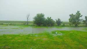
Flooding or run-on potential can be determined by evaluating whether the site is near a perennial or ephemeral stream or wash. If it is within 50 to 100 feet, doing some additional flood investigation may be necessary. Location in a depression or on the edge of a depression in the landscape — where water can collect — will make a site unsuitable for installation of a system. Instead of run-on, I used to call this an area subject to ponding.
So what is a geomorphic description? Probably a term not everyone is familiar with, but designers, engineers, inspectors and installers should be. Geomorphic refers to the form of the earth’s surface at that location. Slope direction and shape help define the form. In my area, the landscapes were formed during the last glaciation and the topography is up and down and rolling; it looks kind of like the knuckles on the back of your hand. Slopes are expected to be short and usually not too steep or complex. Knowing this indicates that fitting the system (depending on size) into this area may be a problem or it may not lend itself to the type of system proposed.
Percent slope measured perpendicular to a contour line across the site will help determine whether the site has a slope where it is allowable to put a system. It will also indicate whether the system can be fed by gravity or require a pump. For instance, many codes do not allow installations on slopes greater than 15 percent. Along with elevation, slope can also indicate the amount of cut necessary for the supply piping; all important considerations in design.
Slope percentage is an easy calculation if you know the elevation difference across a specific length perpendicular to the contour. Let’s say I have an elevation change of 1 foot across a 50-foot space that defines the width of the system. Slope is determined by dividing the elevation difference by the horizontal distance and then multiplying by 100. In this example 1/50 = 0.02 x 100 = 2 percent.
The final part of providing the slope information involves identifying slope shape. I have not seen a lot of places require this, but in terms of a geomorphic description it is an important component. Slope description gives a picture of the land surface along and perpendicular to the slope. So it speaks to the shape of the slope. There are three terms used: linear, which means straight; concave - curved down; and convex - curved up. So describing the land in both directions along and perpendicular gives nine potential combinations.
CHECK THE DIRECTION
A slope described as concave-concave (CC) indicates an area where surface and groundwater flow would collect, which could hydraulically overload a system unless something is done to prevent the flow. It is probably good to avoid installing a system on this area. Slopes that have shapes that are linear-concave (LC), convex-concave (VC) or concave-linear (CL) should be approached cautiously. Since groundwater often travels the same path, it is common to have higher water tables at the foot of these slopes.
One other piece of slope information can be useful. That is the aspect of the slope. What direction does it face? In general, south- and west-facing slopes will be warmer and drier, which could mean an earlier start to a system in the spring or after a rainy period. North- and east-facing slopes will be cooler and wetter, so a slope of the same steepness in similar materials — but facing north — may have problems with seasonal soil saturation.
It may not be important for pumpers and installers to remember the shape names. But recognizing the features in the field and adjusting plans accordingly is important.
Continue reading for free