A topographic map of the site of a proposed sewage treatment system can be very helpful to both the site evaluator and designer. Information can be obtained about land slope, drainage and depressions by looking at a topographic map.
A topographic map is a scale diagram with lines connecting points of equal elevation. There are different scales of topographic maps available. There are U.S. Geological Survey maps available where the contour interval is a line between 10 and 20 feet in elevation difference. Maps at this scale are of limited use for specific onsite system location. However, they can identify landscape characteristics indicating potential problems for systems. These include areas of steep slopes or escarpments, the presence of major drainageways or washes, depressions and areas of potential water ponding.
The most useful contour maps for site evaluation are those prepared by land surveyors specific for lot development, often as part of a subdivision. These maps typically have scales of 1 inch equaling 10 to 20 feet with contour intervals of 2 to 5 feet. Maps at this scale give a good picture of the exact location for the sewage treatment system.
Maps at larger scales are still useful in the siting and design process as indicated above. The relationship of these contour lines to one another indicates elevation. When the lines are spread apart, it means there is a flatter slope with less change in elevation. Likewise, if the contours are closer together, it means that the slope is steeper with changes in elevation occurring in small distances. The designer can use this along with soil information to determine the kind of system best for the site and whether distribution can be by gravity or if a pump and pressure distribution is required.

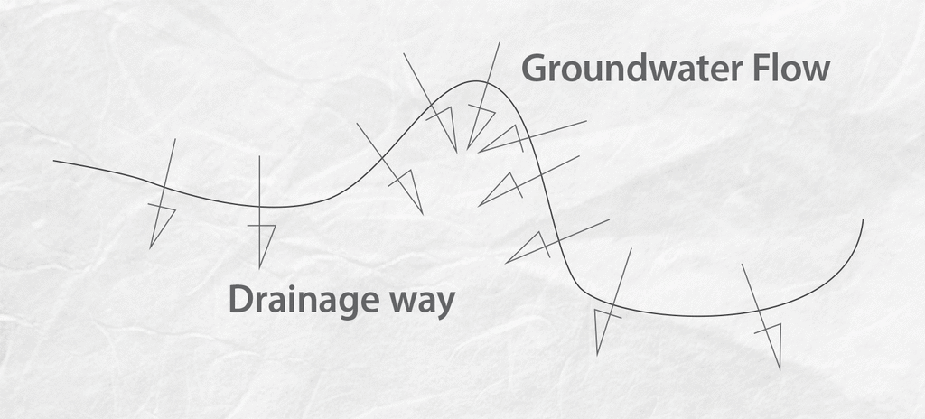
Contour lines can show areas of depression. On a contour map, these lines are shown as hatched lines rather than solid lines. Obviously depressions should be avoided for the location of any part of a sewage treatment system to avoid potential for flooding and infiltration into the system.
Similarly, contour lines that appear concave on the site map indicate the presence of drainageways or pathways where water will run and collect. Remember: Water always runs perpendicular to contour lines. When the lines are concave it means water collects from three sides into a concave area in the middle.

If your sewage treatment trenches are located in these areas, they have the possibility of collecting both surface and subsurface water flowing in these directions. It is a sure recipe for system failure. If the system is an aboveground mound or at-grade system, the same problem applies. It is amazing to me how many times I see a mound installed because the water problem was recognized but the primary direction of flow for surface and subsurface water was ignored. When they are oriented in this direction, the linear loading rate for the soils is easily exceeded, causing water to surface out the toe of the system dike.
About the author: Jim Anderson is connected with the University of Minnesota onsite wastewater treatment program and is an emeritus professor in the university’s Department of Soil, Water and Climate. Send him questions about septic system maintenance and operation by sending an email to kim.peterson@colepublishing.com.
Continue reading for free