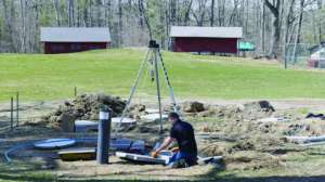
When it comes time to draw onsite system plans and site plans for soil tests, the method many of us have used for years is the laser level out on the site setting benchmark, elevations and contour lines. We determine measurements on site from all the necessary setbacks such as wells, lot lines, buildings, etc. Then once we head back to the office, we draw the site using the data collected at the site.
Newer technology aids in making site plans faster, easier and more accurate. What are some of the newer technologies being used?
Field data gathering
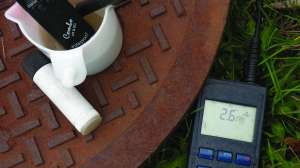
For field data gathering some of the newer technology includes GPS receivers or global navigation satellite
system receivers.
GNSS (global navigation satellite system) uses more satellites, so this system has higher accuracy and less chance of being blocked by physical obstructions.
GPS (global positioning system) has more limitations than the GNSS system has, making the GNSS system more accurate with fewer limitations. GPS uses fewer satellites, so limitations include signals being physically blocked by weather, hills, trees or other obstructions. I’ve experienced issues on wooded sites.
In many cases, the use of this type of receiver reduces field time (or at least reduces the number of tasks) and increases accuracy. By using these tools to locate the soil borings, the elevations and measuring are all performed simultaneously.
Both types of receivers have a wide range of prices. When researching for this article, a surveyor recommended I attend a local surveyor association meeting or annual conference, where pros and cons (and training!) are in abundance. So maybe look to a local surveying organization if you have specific questions about these types of receivers.
Back at the office
A company that performs soil testing and system design claims that by using the types of tools mentioned above, they forward all of the info electronically to their office, and the site plans are generated by the time they get back to the office.
AutoCad
I talked to their surveyor who generates the site plans and he said that after being a surveyor for years his favorite drawing tool is a 1999 version of AutoCad. He likes the older version because he said it’s one he is comfortable with; it has fewer “bells and whistles” than newer versions, which to him makes it easier to use.
For this article I talked with quite a few people who use AutoCad for their site drawings and system designs. They all agree that AutoCad has a big learning curve. I remember taking an introductory AutoCad class decades ago and it was hard then. The agreement among users seems to be that the newer the AutoCad, the harder it is to learn.
AutoCad is the standard by which others will be compared, but expect a long learning curve if you have not used it. AutoCad is also expensive. The value of newer versions of AutoCad lies in how much 3D they can add because most users use it to draw multi-floor buildings, but this is something most of us onsite installers are not doing.
One benefit of using AutoCad would be if you are designing systems for a builder and they want to add your design into their plans, it would be easier to integrate the plans.
Microsoft Visio Professional
I’ve had a couple soil testers and designers tell me they use Microsoft Visio Professional. This seems to be like ‘Word on steroids’ and as such, the learning curve might be somewhat less than AutoCad.
Visio also claims to integrate AutoCad files, so if a customer had the site plan in AutoCad already, Visio claims that they can integrate the AutoCad file that you would download.
Specific to onsite systems
A cursory online search brings me to a software formerly called New Septic but now called landplan.io. This website claims to be septic specific drawing software so specific that it’s based on local codes and integrates with county GIS sites. Obviously codes and regulations are different everywhere, but their website claims that they are up and running for the following states: Indiana, North Carolina, Ohio, Tennessee and Washington. I don’t know anything about this one, but if it does what it says it does, this looks like a really good start.
I am doing a survey of what software you use to draw onsite system plans and site plans for soil tests. For a future article, let me know what software you use to draw systems and site plans. What are the pros and cons are of the program you use? What do you like about it, and what features do you wish were better? Please email your input for this article to todd@herrcorp.com.
We will dive into each of these deeper in another article. Thank you!
Continue reading for free